Pages

Sunday, August 24, 2014

Day 64: Lake Tahoe

August 24, 2014
Lake Tahoe

Day 64 62 miles

I was able to get off the busy highway I was traveling on and found a mini meadow near a cross country ski trail. I enjoyed my personal mini meadow so much I had a hard time leaving it this morning. I lollygagged and finished my book.

I made it to Lake Tahoe, which is beautiful, but the steep hills and lots of traffic made cycling rather difficult. It was also Ironman Lake Tahoe day, so there were lots of triathletes running and biking around.  Apparently this is the best photo I took of the lake. I messed up.


After going around half the lake, I finally decided to stop and swim.The water is clear and just barely cool enough to be refreshing without being too warm.


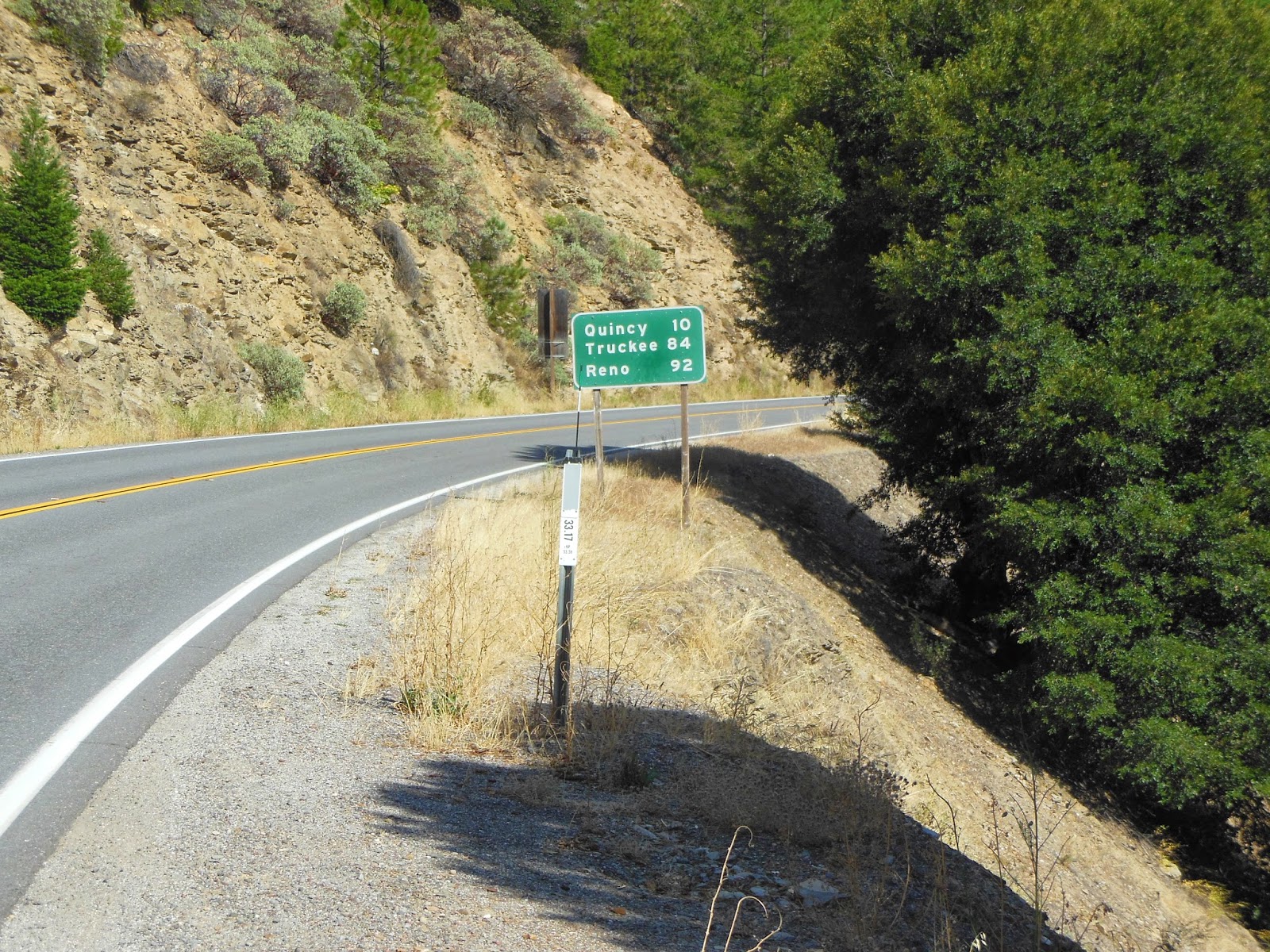
South of Lake Tahoe is another long pass.


After the pass is a long, steep descent. Note the lower right corner. Max speed 51.4 miles per hour. Land speed record.


I had to do some after sundown/dusk riding. There is a lot of private land and I wanted to make it at least to this camping area.

After going to the bathroom, picking a tent spot, and cooking a meal, I realized I didn't have a tent. I realized it must have been stolen while I was in the bathroom which would explain why my bike was tipped over when I got out.

Turns out it wasn't stolen. I found it on the steep bumpy road between the park and the campground. I need to secure it better in the future.

False alarm!

2 days from Yosemite! Need to send postcards and update blog. It has been a long time!

Saturday, August 23, 2014

Day 63: Quincey to Truckee

August 23, 2014

Day 63 Quincey to Truckee
68 miles

The road conditions have improved a little from yesterday's deathtrap and I am getting used to them so today was more pleasant than yesterday.

Not much happening, just getting into some weird moods and singing a lot to myself:


And trying not to worry about this. Guess I'll have to release that pet squirrel I've been carrying around.

Friday, August 22, 2014

Day 62: Lassen to Quincy

August 22, 2014

Day 62: Lassen to Quincy

72 Miles


Today's ride would have been a lot more fun if still had a death wish.

Today featured some of the most horrendous riding conditions of the entire trip. By far the most dangerous, for there were no shoulders at some points, many blind curves, and higher vehicle speeds than any other dangerous road to this point. To put more clearly, out of all the roads I have been on, the stretch of Highway 89 between Indian Valley to Quincy has the worst shoulder AND the worst visibility, AND the sharpest, blindest blind corners, AND the softest shoulders where they do exist, AND the highest vehicle speeds. The only thing that could have made it worse is if the road had more snakes or cracks or potholes in it. I had to run off the road just about every minute to let vans, cars, and logging trucks pass by. Many logging trucks.

Sample 1: Note the rocks jutting up vertically from the paint.


Sample 2: Notice the guard rail is no longer present.


Now imagine logging trucks coming from both directions on those roads. Not pleasant.


So tonight I am thankful to be alive. The scenery was fabulous. But it was like going out to eat with your friend's hot girlfriend: You want to look and stare but if you do you'll be dead. I neither looked at it much or took any photos because I wanted to live another day.


I also have not matured at all on this trip.


Thursday, August 21, 2014

Day 61: Lassen National Park

August 21, 2014
Day 61
Lassen Volcano

Giddy ecstasy that comes from climbing and descending formidable mountain slopes filled the day. Started day at 4000ish feet and made the summit at 8521 feet, then descended back down from there. I think that is more vertical climb than Minnesota has feet above sea level. (it's more than double, actually)


Lassen National Park is very interesting! It's the first recorded volcanic erruption in the United States, in 1914, and one of the oldest national parks. It has all sorts of great views of mountain slopes, rock formations, forests, burn areas, it is a beautiful park. And I think I had the best views while descending, which is always nice. It compounded the pleasure of the downhill.

At Summit pass I went to the trialhead to go to the mountain summit, but the last mile was closed for repairs.


It was still a great view from the closure.


Great day of riding, great campsite, satisfaction.


The pinecones are big. This one is average.

Wednesday, August 20, 2014

Day 60: McCloud River to Old Station

August 20, 2014

62 miles
McCloud River to Old Station

Woken up by elk calling out to each other. One must have been 100 yards or closer to my tent! Did not see it though, and did not hear any more of it after I got up and started packing up. Also heard some owls calling! It was the classing Who! Who who!


Sun rising close to 6:30, which is problematic because it means the days are getting much shorter, and I have less time to get miles in, less time to rest, less time to find a good camping spot. As I type this it is 9:00 and there is no sign of the sun. I had my tail light on at 6:30, and by 7:30 I needed to be off the road. Such a change from the first 2 weeks of the trip when we could bike all night if we wanted!


Cm carrying en 3xtra 64 ounces of water. I like the peace of mind knowing that I can travel farther without needing to stop for water, or have to ration it wheile riding. It is so hot I go through I lot of water.


The riding ahs been through all different kids of landscapes. There has been more shrubland mixed in with the trees. I'm going through a very recent burn area. Some of the roads are still closed, and I see firefighters rushing by frequently. I stopped to swim in Hat Creek, which was closed but I'm a rule breaker so I went in.


Am camped a mile or two past Old Station along the confluence of two creeks. I think I may be in an Elk bedding grounds. Hopefully they don't come back in the middle of the night to sleep!

Tuesday, August 19, 2014

Day 59: Mt. Shasta to River Road Loop hwy 83

After ditching my gear behind some bushes, I went up to Panther Meadows, just at the treeline on Mt. Shasta.

Oh no the trees are sideways!


Oh no now the land is sideways!


What is amazing about the mountain is how quickly its features change. You go from Alpine meadows to rubble to forest to a completely different kind of rock all within one mile of walking. These photos are on a trail to South Gate Meadow.


Hiero!


The descent that took me over 2 hours to climb was over in about 20 minutes. I love biking downhill.

I made it to a nice quiet road that had lots of water going around it. I swam in this nasty, stagnant water before I learned that there is a much nicer swimming hole down a short trail.


Oh well. I got to clean myself from this:


to this:

Monday, August 18, 2014

Day 58: Yreka to Mt. Shasta via Weed

August 18, 2014

An identity crisis at the Sacramento River Headwaters was the highlight of today, but we will get to that.

First I made it to Weed, Oregon, to take my picture in front of the classic sign we all know and love:


But unfortunately it got stolen so often they changed it to this:


It's just not the same. I was disappointed. But if you ever go there, you can go to the gift shop where they have all sorts of clever posters and signs with the city name.

This sign was funny. though


Then I made it to Mt. Shasta where I had a severe identity crisis, for the hippies of Mt. Shasta are on a whole new level that I never new existed. I am no longer sure I can call myself even a little bit of a hippie after seeing them.

On what I assume was an average Monday afternoon, I heard more pan flute, impromptu conga solos, and recorder playing than I have in my life. And I couldn't even count the number of men in skirts and vests, and  braless women in what I think are homesewn dresses and dashikis.

They were filling up water jugs from the headwaters because it's known for being great water. Or, as one hippie said "I don't know why, but I'm naturally drawn to this water." I also heard the words pure, natural, and "Evolving into a higher states of consciousness," very often.

I was intrigued, and so I sat and people watched for a long time in the park while I contemplated about why it is that I think I like hippies, but am so put off by what I was seeing at Mt. Shasta. I will likely be thinking about this for weeks to come while I'm on my bike. What I concluded when I left was that I like hippies because they are different from normal, but in Mt. Shasta they are the norm, and that made me feel funny.

When I biked down main street, there were a bunch of hippies outside the music store playing with the didgeridoos. It was bizzare.


The scene at the headwaters was hard to break away from. There was so much going on, and so many hippies that brought out my curiosity!


I decided to take a day to hike around the base of Mt. Shasta, so that necessitated a 14 mile bike ride uphill. On top of the 50 I had already done.

I only made it 9 miles set up camp, and decided I could do the last 5 miles without all my gear which will be helpful.

At the hight I was the sunset was very cool to watch, many fun colors that you can sort of see here.